

DESCRIPTION EAST-WEST
Route: Mojstrana – Gozd Martuljek – Kranjska Gora – Rateče – Peč (Tromeja) – Korensko sedlo
Start: Slovenski planinski muzej Mojstrana (altitude 643 m)
Destination: Korensko sedlo (altitude 1.070 m)
Today’s stage has two faces: the first part leads us leisurely through the tourist besieged towns of the Upper Sava Valley, and the second part takes us along the lonely forest roads to the highest point of the day where the borders of the three countries – Slovenia, Austria, Italy – meet.
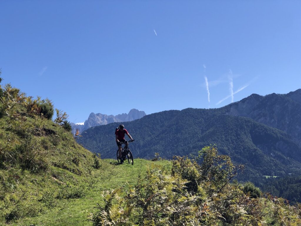
From the museum, we descend for 500 m through Mojstrana along the Triglavska Street and turn left onto Jakob Aljaž Street. After 250 m we turn right onto a smaller path and an avenue that leads to the bridge over the Sava Dolinka river. We turn left here. The navigation challenges are over for a while, as the well-maintained and marked D2 cycling route will take us up to Rateče village which is 19 km away and 220 vertical meters higher. We pass Belca and through Gozd Martuljek. If we like the hustle and bustle of downtown Kranjska Gora, we can also refresh ourselves there, otherwise we continue below the famous ski slopes and bike park towards Podkoren, past Zelenci, the source of Sava Dolinka river, to Rateče. At the roundabout we cross the main road and after 200 m turn left through the village. At the well in the middle of the village we can get some fresh water, and at the end of the village we branch off to the side road that leads up towards Tromeja. The climb is 6.5 km long with an altitude difference of 600 m. The asphalt soon turns into a gravel road, along the way we are accompanied by information boards where we can learn more about landscapes and activities in mountain pastures and forests above Rateče.
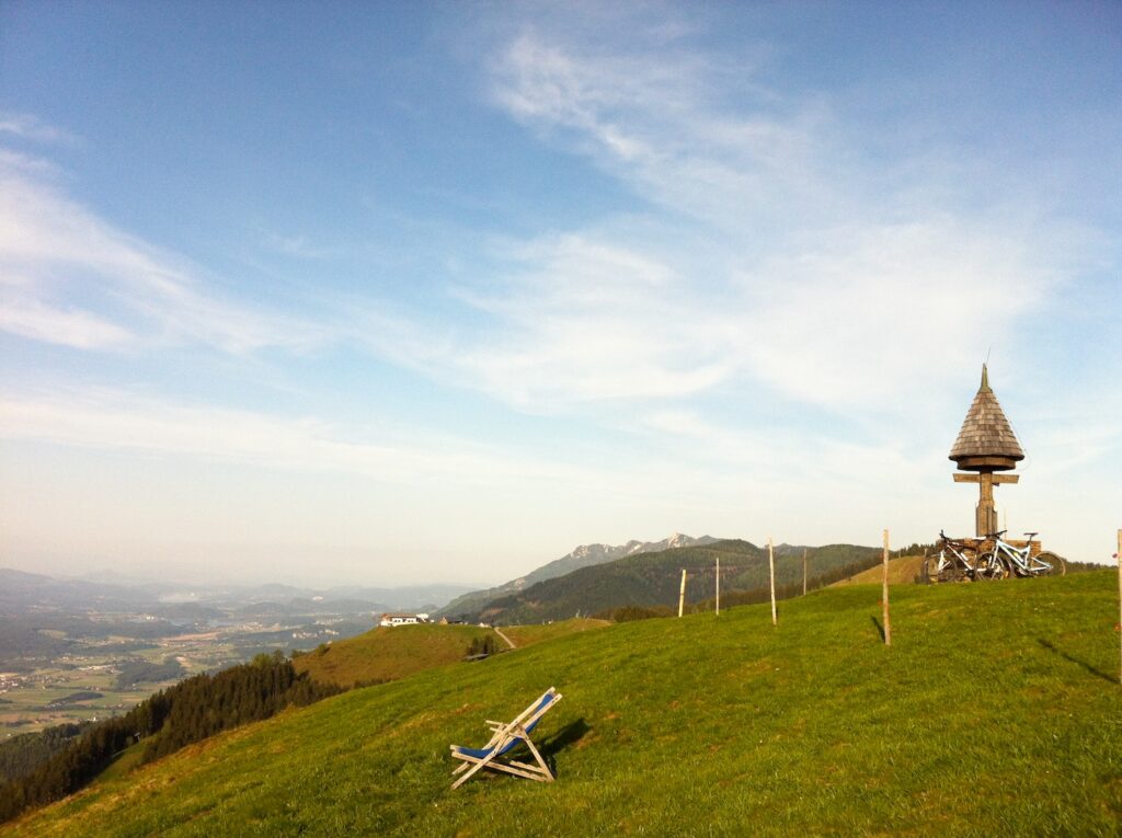
At the intersection after 2 km we continue left upwards, also going left past the fork for Dom na Tromeji which is unfortunately closed. Another turn follows, we also go left up here. Soon we will see meadows on the right, which are part of the ski resort on the Austrian side, and the last couple of switchbacks bring us right to the top. The peak offers a magnificent view of the Julian Alps to the south and the Ziljska valley (Gailtal), Dobrač and Carinthian lakes to the north. You have the unique opportunity to stand on the border point of three countries – Slovenia, Austria and Italy.
The tour ends with a descent to Korensko sedlo. We ride back on the road where we climbed, at the intersection after 2.5 km we turn sharp left. The gravel road is mostly descending for another 5 km until a kilometer before the finish it connects to the main road. We turn sharply left towards Korensko Sedlo, where we can congratulate ourselves as we completed the Trans Karavanke MTB Trail!
DESCRIPTION WEST-EAST
Route: Korensko sedlo – Peč (Tromeja) – Rateče – Kranjska Gora – Gozd Martuljek – Mojstrana
Start: Korensko sedlo (altitude 1.070 m)
Destination: Slovenski planinski muzej Mojstrana (altitude 643 m)
We begin our journey through the Karavanke mountain range at the Korensko sedlo border crossing. On the busy main road, we descend for one kilometer towards Rateče, then turn sharply right and we are already on a gravel road. The ascent is not too demanding, in the next seven kilometers we will climb for 400 meters, but it is true that the road also includes some short downhill sections. After five kilometers you should not miss the sharp right uphill turn followed by another 2.5 kilometers to the peak. Soon we will see meadows on the right, which are part of the ski resort on the Austrian side, and the last couple of switchbacks bring us right to the top of Peč, where borders of three countries (Slovenia, Austria, Italy) meet. The peak offers a magnificent view of the Julian Alps on the southern side and the Ziljska valley (Gailtal), Dobrač and Carinthian lakes to the North.
We will descend on the same road for 2.5 km, this time turn right at the crossroads and continue downhill towards Rateče. We pass the junction for Dom na Tromeji which is unfortunately closed. The whole descent is 6.5 km long, above Rateče we come from the woods to pastures and slowly descend into the village. Along the way we are accompanied by information boards where we can learn more about the landscape and activities in the pastures and forests above Rateče.
There are some good pubs in Rateče where we can refresh ourselves, fresh water can be found at the well in the middle of the village.
If the first part of the stage was on the lonely forest roads, the second will be its opposite – we came to the popular tourist area of the Upper Sava Valley, where the hustle and bustle of the road to Mojstrana is difficult to avoid. There will also be less navigation dilemmas, following the marked D2 cycle path for 19 kilometers to our destination. We ride through Rateče towards the east and at the end of the village turn right towards the main road. At the roundabout we cross the main road and head along the cycle path that takes us to the old railway line. If we have enough time we can turn to Planica Nordic Ski Center here, which is only two kilometers away. Otherwise, we turn left towards Kranjska Gora. We will cycle past Zelenci, the spring of the Sava Dolinka River, and through Podkoren. Under the bike park and famous ski slopes we reach Kranjska Gora. We continue along the D2 cycle path through Gozd Martuljek and past Belca. When we reach Mojstrana we turn right across the bridge over the Sava Dolinka River, through the avenue towards Jakob Aljaž Street and then some 250 m to the right onto the main Triglav Street. The destination of today’s stage is 500 meters away at the Slovenian Alpine Museum.
Caution! During the summer months, livestock grazes on the plains of the Karavanke mountains, so we must close the gates behind us and do not disturb animals with aggressive riding.
Sights along the route:
- Zelenci – the source of Sava Dolinka River
- Lake Jasna above Kranjska Gora (1 km detour)
- Planica Nordic Ski Center (2 km detour)

